


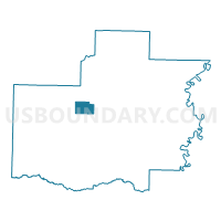
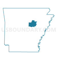
Crosby Voting District, White County, Arkansas
About
Outline

Summary
| Unique Area Identifier | 528504 |
| Name | Crosby Voting District |
| County | White County |
| State | Arkansas |
| Area (square miles) | 9.63 |
| Land Area (square miles) | 9.63 |
| Water Area (square miles) | 0.01 |
| % of Land Area | 99.93 |
| % of Water Area | 0.07 |
| Latitude of the Internal Point | 35.29720040 |
| Longtitude of the Internal Point | -91.84702030 |
Maps

Graphs
Select a template below for downloading or customizing gragh for Crosby Voting District, White County, Arkansas


Neighbors
Neighoring Voting District (by Name) Neighboring Voting District on the Map
- Des Arc Voting District, White County, AR
- Gray B Voting District, White County, AR
- Mt Pisgah Voting District, White County, AR
Top 10 Neighboring County Subdivision (by Population) Neighboring County Subdivision on the Map
- Gray township, White County, AR (25,007)
- Des Arc township, White County, AR (951)
- Crosby township, White County, AR (607)
- Mount Pisgah township, White County, AR (106)
Top 10 Neighboring Unified School District (by Population) Neighboring Unified School District on the Map
Top 10 Neighboring State Legislative District Lower Chamber (by Population) Neighboring State Legislative District Lower Chamber on the Map
- State House District 50, AR (32,318)
- State House District 49, AR (32,244)
- State House District 59, AR (29,163)